Introduction
 |
| |
AutoCAD permits three kinds of 3D modelling:
- wireframe modelling– uses 3D lines, arcs, circles,
and other graphical objects to represent the edges and features of an
object; so-called because the model looks like a sculpture made from
wires.
- surface modelling – takes 3D modelling one step further to
add surfaces to the wireframe so that the model can be shaded and
hidden lines removed. A surface model is like an empty shell: there's
nothing to tell you how the inside behaves.
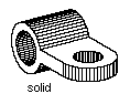
- solid modelling – a solid model is most like a real object
because it represents not only the lines and surfaces, but also the
volume contained within. When you create a solid modelled drawing
database, in some ways it is as if the actual object were stored
inside the computer. Creating a solid model is somewhat like sculpting
a piece of clay. You can add and subtract material with Boolean
operators and create parts by revolution and extrusion.
|
Co-ordinate Systems
|
| 3D Systems |
Working effectively with CAD means being
able to create 3D models of an object and then convert them to 2D
drawings. One difficulty in AutoCAD, and many other types of modelling
programs, is creating this type of model relies heavily rely on your
understanding of the Cartesian Co-ordinate System, and your ability to
relate it to the model in space. In this and other programs you must
change the orientation of the XYZ planes to suite the needs of the
drawing process. In AutoCAD, the variations of the Cartesian System are
referred to as the User Coordinate System, and allows you, not only to
orient yourself to a model, but also reposition the location of the
origin point (0,0,0) and the X,Y and Z axes for drawings.
Three-dimensional geometric modellers extend the capabilities of
two-dimensional drafting systems by providing a rich set of features to
construct, transform, and project 3D geometric forms as collections of
lines, surfaces, and volumes in space. In modelling systems, such
geometric objects are usually constructed within a 3D Cartesian
co-ordinate system, an extension to the 2D version introduced in an
earlier tutorial. Point locations are described by x, y, z co-ordinate
triplets. |
| Right-hand
or left-hand
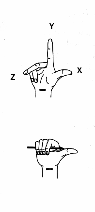
|
There are so-called right-hand and
left-hand cartesian co-ordinate systems depending on the
direction of the positive z axis. Using the hand analogy, the thumb
indicates positive direction of the x axis, the index finger positive
direction of the y axis, and the middle finger the positive z axisThe
difference between using the right or left hand to determine orientation
is that the direction of the positive z axis is reversed.
To determine the positive rotation direction about an axis, point
your right thumb in the positive direction of the axis and curl your
fingers as illustrated. Your curled fingers indicate the positive
rotation direction about the axis.
AutoCAD employs the righthand 3D Cartesian co-ordinate system.
In fact, AutoCAD supports all three co-ordinate systems: 3D cartesian,
cylindrical, and spherical. d Cartesian co-ordinates are specified as x,
y, z triplets. Cylindrical co-ordinates are specified using the
following convention: Distance<Angle, Height(z)—e.g., 5<45,4. Spherical
co-ordinates are specified as Distance<Angle in xy plane<Angle from xy
plane—e.g., 5<45<60. Relative 3D co-ordinates are preceded by the @
symbol—e.g., @5,4,2 |
Construction Planes
|
| |
How does one draw 2D shapes or
construct 3D forms on vertical or slanted planes in space? Before such
objects can be drawn, new reference or construction planes
must be defined.
In most 3D modelling systems, there is a "global" or "world"
co-ordinate system, defined by origin point and x, y, and z axes.
Additional local co-ordinate sysems, often referred to as reference or
construction planes, can be defined by giving co-ordinates of 3 points
that lie on it, or by rotating about one of the co-ordinate axes. Using
these and other methods of definition, a new construction plane can be
created to coincide with any surface in the model.
In AutoCAD, the user defined reference or construction plane is
called the User Co-ordinate System or UCS.
|
| WCS & UCS |
|
| Defining
construction planes |
To define a UCS, enter the UCS command and select
one of the options, or choose UCS from the Tools menu. A
UCS can be specified by three points in space, rotation about x, y, or z
axis, alignment with an object, translation of the origin, direction of
the origin, direction of the positive z axis, or alignment with the
current view plane.
Use the Save option to store UCS definitions, and use the
Restore option to reuse them. |
| 3D
Geometric Primitives |
Typically, a modelling system's vocabulary includes
boxes, wedges, pyramids, cylinders, cones, and spheres. Additional 3D
geometric primitives can be constructed from 2D shapes by sweeping or
skinning operations.
Each of these primitives can be created as a:
- wire-frame object – composed of curvilinear elements, lines and
curves in space, and appear as if composed of "wires".
- surface object – composed of surfaces without thickness, or
- solid (volumetric) object – these have volume and are completely
enclosed.
AutoCAD can create all three types of 3D primitives: wireframe,
surface, and solid.
Whether an object is a surface or a solid will determine what can be
done with it. For example, there are powerful editing and data
extraction operations applicable only to solid objects. |
|
| Sweeping
Operations |
Additional 3D geometric primitives can be constructed
from 2D shapes through sweeping operations. A 2D shape can be translated
from its construction plane to form a 3D object. For example, a cone can
be created by rotational sweeping of an inclined line.
AutoCAD supports both translational and rotational sweeping, and
sweeping along an arbitrary path. Translational sweeping is referred to
as extrusion, and rotational sweeping as revolution. |
| Skinning
Operations |
3D objects can also be created by drawing a sequence of
profiles (2D sections) over which a 3D object (surface or solid) can be
created. This is called skinning. There are two skinning
methods:
- ruled – 2D profiles are connected with ruled surfaces, whereby
continuity is disregarded, i.e., sharp transitions can exist between
surfaces.
- lofted – continuity is maintained—the resulting surface will be
smooth, without sharp edges or corners.
|
| |
|
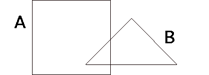
| Boolean
Operations |
Most modellers allow the set operations of union,
intersection, and subtraction—the so-called Boolean
operations. Since 3D geometric objects created by 3D modellers are
nothing more than sets of interrelated points in space, the Boolean
operations are provided to create composite surfaces and volumes.
 |
|
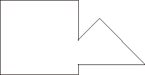 |
A union B |
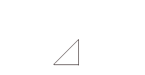 |
A intersect B |
 |
A subtract B |
 |
B subtract A |
Applying Boolean operations to simple 3D geometric primitives can
easily create some rather complex 3D forms.
AutoCAD supports all three Boolean operations: union, intersection,
and subtraction. 3D solid objects can also be created by slicing. |
Basic 3D Operations
|
| |
3D objects can be inserted and selected, and once
selected, can be deleted, transformed, or replicated. A 3D object is
inserted by selecting the appropriate modelling tool, such as box,
cylinder, etc., and by locating points and assigning values to
parameters that define it.
As before with 2D CAD drawing, an object must be selected before it
can be deleted, replicated, or transformed. As with
2D objects, the four Euclidean transformations of translation,
rotation, reflection, and scaling can be performed on
3D objects.
In AutoCAD, the standard 2D rotate and mirror commands have 3D
complements: 3D Rotate and 3D Mirror. 2D Rotate performs
rotation about a point in the xy plane of the current UCS, and 3D Rotate
performs rotation about an axis in 3D space. 2D Mirror performs
mirroring about an axis in the xy plane, and 3D Mirror about a plane in
space.
AutoCAD provides attaching of objects through the align
command. 3D objects can be aligned by a point, edge, or face.
In AutoCAD, trim, extend, fillet, chamfer, and
stretch operations have limited application to 3D objects.
Surface objects cannot be trimmed, extended, filleted, or chamfered—they
can be stretched, however. Solid objects can be trimmed by slicing but
can't be extended or stretched; they can be filleted or chamfered.
3D objects can be copied or arrayed anywhere in 3D space in AutoCAD.
You cannot, however, offset 3D objects. As in 2D, copy creates
exact duplicates of existing objects. Array replication creates
circular (polar) and rectangular patterns of selected objects on a 2D
plane, or cylindrical and prismatic patterns in 3D space. Offset
creates at a specified distance or through a selected point a new object
similar in form to the original. |
|
Topological Editing |
Meshed surface objects can be modified in AutoCAD by
manipulating grips, located at mesh vertices. To display grips, click on
one of the surface objects in 3D space. AutoCAD supports topological
editing of surface but not solid objects. Vertices, edges, and facets of
surface meshes can be manipulated, i.e., translated, rotated, etc.
To move a grip, click on one and drag it to a new position then
release the mouse button. The surface object thus changes shape.
 Handles or "grips" Handles or "grips"
|
|
Structuring 3D Models |
Structuring concepts from 2D drawings such as symbols,
layers, groups, and external references, are applicable to 3D models as
well.
Layers in 3D modelling cannot be seen as analogous to transparant
sheets, because the contents of layers can intertwine in 3D space.
Therefore, the layers in 3D modelling can be best described as named
parts of the model that contain objects with similar content.For
example, the layer named 3-DOORS can contain 3D objects that represent
the third floor doors.
As in 2D drawing, 3D models can also be structured by grouping
objects into hierarchies, and by using external references. For example,
each floor of a building can be stored in a separate file, whereby files
containing other floors are externally referenced for 3D construction
and display purposes. |
| Viewing |
Geometric models are created in a virtual 3D space that
is then projected to a 2D surface of the computer display. Using
one of the projection methods—orthographic, axonometric, oblique, or
perspective—3D co-ordinates of points in space are converted into xy
co-ordinate pairs in the 2D plane of the display.
In traditonal projective geometry, projections are created by
establishing a picture plane somewhere in space and casting projection
rays from points in space toward the picture plane. In computer
graphics, projections are created by mathematics applied to xyz
co-ordinate triplets. For example, plan projection is created by
discarding the z co-ordinate.
AutoCAD does not support oblique projection. Orthographic,
axonometric, and perspective projection methods are fully supported.
The creation of a perspective projection simply involves choosing the
perspective option in one of the menus. However, if a specific
perspective is wanted, from a particular viewpoint, the set-up requires
that several parameters be provided:
- location of the viewpoint referred to variously as the eye or
camera,
- location of the target point,
- viewing angle, and
- location of the front and back clipping planes.
The view (eye) and target points define the line of sight, which,
with the viewing angle, defines the cone of vision or, as it is
often called, the viewing pyramid.
AutoCAD uses a camera metaphor in setting-up a perspective
projection. To change the viewing angle, adjust the zoom lens length.
The camera can also be twisted and panned.
Some modellers offer depth clipping to eliminate from the
scene those objects that lie in front or in back of the viewing pyramid.
This is done by specifying the distance of the front and back clipping
planes from the viewpoint..
Most modellers can simultaneously display more than one projection.
Typically, the program's window is sub-divided into four viewports, each
displaying a different projection: top, front, right, and axonometric or
perspective. In AutoCAD, the number, content, and configuration of
viewports can easily be set-up and changed. From the View menu,
choose Tiled Viewports, then Layout, to subdivide the
graphics area into several viewports, and then set-up the desired
projection in each viewport. |
3D Primitives
|
| Wireframes

|
If solid modelling is so much more
realistic than the other types why then is not more made of 3D models.
Wireframe representation is usually used to make drawing operations
quicker.
The model you've created in the exercises of earlier tutorials was
displayed in wireframe mode. Wireframes show only the edges of
a model, and the model appears to be transparent. You can
think of the lines that make up a wireframe as "wires" that indicate the
model's edges.
Wireframes can be difficult to interpret because they are
transparent; however, they are easier for the computer to display so
they are AutoCAD's default method of displaying a 3D model. If the model
was always displayed on the screen as a solid it would take considerable
time for the computer to display changes you make in the model because
of the number of calculations the computer would have to make to
regenerate the figure. This would slow down the fuctioning of the
program to a crawl. |
| Surface
Modelling
|
Surface modelling is more sophisticated
than wireframe modelling in that it defines not only the edges of a 3D
object, but also its surfaces. AutoCAD's surface models are composed of
a faceted polygonal mesh that approximates curves surfaces
because the faces of the mesh are planar. The Surface
toolbar (see below) contains selections for 2D Solid, 3D Face, Box,
Wedge, Pyramid, Cone, Sphere, Dome, Dish, Torus, Edge, 3D Mesh. Revolved
Surface, and Edge Surface |
| Solid
Modelling
|
Solid modelling is the easiest type of 3D modelling to
use. With AutoCAD's solid modeller, you can make 3D objects by creating
basic 3D shapes: box, cone, cylinder, sphere, wedge, and torus. You can
then combine these shapes to create more complex solids by joining or
subtracting them or finding their intersecting volume. You can also
create solids by sweeping a 2D object along a path or
revolving it about an axis.
What is the difference between surface modelling and solid modelling
in AutoCAD? How do you select one method over the other? Consider the
following points:
- with surface modelling, only the surfaces and not the interior
volumes of the object are described in the drawing database--the
objects created with surface modelling are like empty shells
- a solid model is most like a real object because it represents not
only the lines and surfaces, but also the volume contained within
- you cannot use Boolean operators to join surface models like you
can with solid models
- surface modelling provides less information about the object
- surface modelling is more difficult to use than solid modelling
- surface modelling is better suited to such applications as 3D
terrain modelling
- try not to mix solid modelling and surface modelling (and, for
that matter, wireframe modelling) as you can't edit them in the same
ways to create a cohesive single structure
- surface models can be converted to wireframe models using the
EXPLODE command
- solid models can be converted to surface models using EXPLODE
- however, you can't easily convert wireframe to surface models or
surface models to solid models
|
| Creating
Wireframes
|
In AutoCAD, you can create wireframe models by
positioning any 2D planar object anywhere in 3D space. Positioning 2D
objects in 3D space can be achieved by:
- creating the object by entering 3D points (X, Y, Z)
- setting the default construction plane (XY plane) on which you
will draw the object by defining a UCS
- moving the object to its proper orientation in 3D space after you
create it.
|
| Creating
Meshes
|
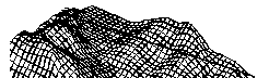
A mesh represents an object's surface using planar
facets. the mesh density, pr number of facets, is defined in terms of a
matrix of M and N vertices, similar to a grid consisting of columns and
rows. M and N specify the column and row position, respectively, of any
given vertex. You can create meshes in both 2D and 3D, but they are used
primarily for 3D.
Use meshes if you don't need the level of detail about physical
properties (i.e., mass, centre of gravity, etc.) that solids provide but
you do need the hiding, shading, and rendering capabilities that
wireframes don't provide. Meshes are useful for modelling terrain—e.g.,
a building site.
A mesh can be open or closed. A mesh is open in a given direction if
the start and end edges of the mesh do not touch (see figure below).

AutoCAD provides several methods for creating meshes. Some of these
methods can be difficult to use if you are entering the mesh parameters
manually, so AutoCAD provides the 3D command, which simplifies the
process of creating the basic surface shapes. |
| (i)
Creating a Pre-defined 3D-surface mesh
|
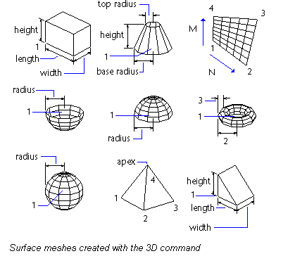
The 3D command creates the following 3D shapes: box,
cone, dish, dome, mesh, pyramid, sphere, torus, and wedge. These are
meshes that are displayed as wireframes until you use HIDE, SHADE, or
RENDER.
To view the objects you are creating with the 3D command more
clearly, set a viewing direction with VPOINT or DVIEW. Below are
examples of surface meshes created with the 3D command.
|
| (ii)
Creating a rectangular Mesh

|
With the 3DMESH command you can create polygon meshes
that are open in both the M and N directions (similar to the X and Y
axes of an XY plane). You can close the meshes with PEDIT. You can use
3DMESH to construct very irregular surfaces. In most cases, you can use
3DMESH in conjunction with scripts when you know the mesh points.
Try this exercise: To create a rectangular mesh:
1. from the Draw menu, choose
Surfaces > 3D
Mesh
2. specify the M size, using an integer from 2
through 256
3. specify the N size, using an integer from 2
through 256
4. specify the vertex points as prompted.
Specifying the last vertex point completes the mesh
Example:
Command:
3dmesh
Mesh M size: 4
Mesh N size: 3
Vertex (0, 0): 10, 1, 3
Vertex (0, 1): 10, 5, 5
Vertex (0, 2): 10, 10, 3
Vertex (1, 0): 15, 1, 0
Vertex (1, 1): 15, 5, 0
Vertex (1, 2): 15, 10, 0
Vertex (2, 0): 20, 1, 0
Vertex (2, 1): 20, 5, -1
Vertex (2, 2): 20, 10, 0
Vertex (3, 0): 25, 1, 0
Vertex (3, 1): 25, 5, 0
Vertex (3, 2): 25, 10, 0
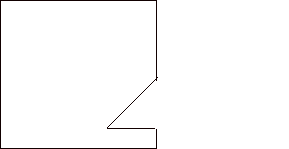
Example of a rectangular mesh – a terrain model. |
| (ii)
Creating a Polyface Mesh
|
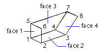
The PFACE command produces a polyface mesh, with each
face capable of having numerous vertices.
Creating a polyface mesh is similar to creating a rectangular mesh.
To create a polyface mesh, you specify co-ordinates for its vertices.
You then define each face by entering vertex numbers for all the
vertices of that face. As you create the polyface mesh, you can set
specific edges to be invisible, assign them to layers, or give them
colours.
To make the edge invisible, enter the vertex number as a negative
value. For instance, to make the edge between vertices 5 and 7 invisible
in the following illustration, you would enter the following:
Face 3, vertex 3: -7
In the figure below:
- face 1 is defined by vertices 1, 5, 6, and 2.
- face 2 is defined by vertices 1, 4, 3, and 2.
- face 3 is defined by vertices 1, 4, 7, and 5, and
- face 4 is defined by vertices 3, 4, 7, and 8
|
| (iii)
Creating a Ruled Surface Mesh

|
With RULESURF, you can create a surface mesh between
two objects. You use two different objects to define the edges of
the ruled surface: lines, points, arcs, circles, ellipses, 2D polylines,
3D polylines, or splines. Pairs of objects to be used as the "rails" of
a ruled surface mesh must both be either open or closed.
To create a ruled surface:
1. From the Draw menu, choose
Surfaces >
Ruled Surface
2. Select the first defining curve. Then select the second (1, 2)
3. Erase the original curve if necessary
You can specify any two points on closed curves to complete RULESURF.
See the figure below.
FIGURE |
| (iv)
Creating a Tabulated Surface Mesh
TABSURF icon |
With the TABSURF command you can create a surface
mesh representing a general tabulated surface defined by a path curve
and a direction vector. The path curve can be a line, arc,
circle, ellipse, elliptical arc, 2D polyline, 3D polyline, or spline.The
direction vector can be a line or an open 2D or 3D polyline. TABSURF
creates the mesh as series of parallel polygons running along a
specified path. See illustration below.
To create a tabulated mesh:
1. from the Draw menu, choose
Surfaces >
Tabulated Surface
2. Specify a path curve (1)
3. Specify a direction vector (2)
4. Erase the original objects if necessary.
FIGURE
The surface is defined by a mesh which, in turn, is defined by a
matrix of M and N vertices. M and N specify the column and row locations
of vertices. Two system variables, Surftab1 and Surftab2 ,
control the mesh density:
- Surftab1 controls the mesh density in the M direction; it
controls the density of the mesh for Ruled Surfaces because they are
always a [2 X Surftab1 + 1] mesh
- Surftab2 controls the mesh density in the N direction
To set the value for Surftab1, for example, enter the command
surftab1
For the new value for Surftab1, enter
40 |
| (v)
Creating a Surface of Revolution Mesh
REVSURF icon |
Use REVSURF to create a surface of revolution by
rotating a profile of the object about an axis. REVSURF is useful for
surfaces with rotational symmetry.
To create a surface of revolution:
1. from the Draw menu, choose
Surfaces >
Revolved Surface
2. Specify a path curve (1)
The path curve, which defines the N direction of the mesh, can be a
line, arc, circle, ellipse, elliptical arc, 2D polyline, 3D polyline, or
spline.
3. Specify the axis of revolution (2)
The direction vector can be a line or an open 2D or 3D polyline.
4. Specify the start angle. Then specify the included angle.
5. Erase the original objects if necessary.
The SURFTAB1 and SURFTAB2 system variables control mesh density in the
M and N directions. |
| (vi)
Creating an Edge-Defined Surface Mesh
EDGESURF icon |
Use the EDGESURF command to create a surface patch mesh,
shown in the figure below, from four objects called edges. Edges can be
lines, arcs, polylines, elliptical arcs, or splines and must form a
closed loop and share endpoints.
To create an edge-defined surface patch mesh:
1. From the Draw menu, choose
Surfaces > Edge Surface
2. Select the four edges in any order (1-4)
The first edge you select determines the mesh's M direction.
FIGURE
The SURFTAB1 and SURFTAB2 system variables control mesh density in
the M and N directions.
|
| (vii)
Setting Elevation and Thickness
|
Thickness and elevation are methods of
simulating meshes in AutoCAD. The advantage of this method instead
of a mesh is that the user can change them quickly and easily for both
new and existing objects.
The elevation of an object is the Z value of the XY plane on
which the object base is drawn. The thickness of an object is the
distance that the object is extruded above or below its elevation.
Thickness changes the appearance of certain geometric objects, such
as circles, lines, polylines, arcs, 2D solids, and points. The user sets
the thickness of an object with the THICKNESS system variable. Once you
have set an object's thickness, you can see the results by going to any
view other than the plan view (see figure below).
Not all objects can have their thickness set: 3D faces, 3D polylines,
and 3d polygon meshes cannot be extruded.
The CHANGE command is used to change an object's THICKNESS property.
The ELEV command is used to establish the current elevation. The current
elevation remains in effect even as you change from one UCS to another.
ELEV defines the drawing plane of the current UCS. |

|
To set the thickness of NEW objects:
1. Choose
Modify >
Properties
2. In the Modify dialog box, enter the thickness settings,
then choose OK
3. Draw the desired objects.
To change the thickness of EXISTING objects:
1. Enter the command chprop
2. Select the objects to change
3. Enter t (i.e. "thickness")
4. Enter the new thickness in units
5. Press Enter to quit the command |
| Creating
Solids
|
Complex solid shapes are easier to
construct and edit than wireframes and meshes. You create solids:
- from one of the basic solid shapes of box, cone, cylinder, sphere,
torus, and wedge or
- by extruding a 2D object along a path or
- by revolving a 2D object about an axis.
Once you have created a solid in this manner, you can create more
complex shapes by combining solids. You can:
- join solids,
- subtract solids from each other, or
- find the common volume (overlapping portion) of solids
- fillet or chamfer solids' edges
- slice a solid into two pieces
- obtain the 2D cross-section of a solid
Like meshes, solids are displayed as wireframes until you hide,
shade, or render them. By exploding a solid, you can break it down to
mesh and wireframe objects. |
| (i)
Creating a Solid Box
|
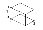
To create a solid box, you use the BOX
command or icon. the base of the box is always parallel to the XY plane
of the current UCS.
To create a solid box:
1. Choose
Draw > Solids
> Box (or choose the icon)
2.Specify the first corner of the base (1)
3. Specify the opposite corner of the base (2)
4. Specify the height (3)
|
| (ii)
Creating a Cone
|
Use the CONE command to create a solid cone
defined by a circular or an elliptical base tapering to a point. By
default, the cone's base lies on the XY plane of the current UCS. The
height is parallel to the Z axis.
To create a solid cone with a circular base:
1. Choose
Draw > Solids
> Cone (or choose the icon)
2. Specify the base centrepoint (1)
3. Specify the radius or diameter of the base (2)
4. Specify the height (3)
With procedures similar to those for creating box and cone (see
above) other 3D solid primitives such as cylinders, spheres, wedges, and
tori may be generated. |
| Creating
an Extruded Solid
|
You can create solids by extruding (adding
thickness to) selected objects via the EXTRUDE command. You can extrude
closed objects such as polylines, rectangles, circles, regions,
etc.
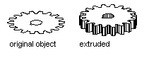
You cannot extrude
- 3D objects
- objects contained within a block (explode the block first)
- polylines that have crossing or intersecting segments, or
- polylines that are not closed
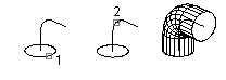
You can extrude an object along a path (see figure below). You
can extrude objects you've created in profile. If you create profile
using lines or arcs, then you must either:
- use the JOIN option of pedit command to convert them to
a single polyline or
- make them into a REGION before you use EXTRUDE
|

|
To extrude an object along a path:
1. Select
Draw > Solids
> Extrude (or choose the icon)
2. Select the objects to extrude (1)
3. Enter p (i.e., "path")
4. Select the object to use as the path (2)
After the extrusion, AutoCAD deletes or retains the original object
depending on user's wishes.
|
| Creating a
Revolved Solid
|
The command REVOLVE may be used to create a
solid by revolving a closed object about the X or Y axis of the current
UCS. The requirements of REVOLVE are similar to those of EXTRUDE (use
PEDIT JOIN to convert lines, etc to polylines). |
| Combining
Solids
|
Solids can be combined (union), subtracted,
and intersected to form composite, or complex, solids. This is
done with Boolean operators. These operations are named for 19th century
logician and mathematician George Boole, who formulated the basic
principles of set theory. In AutoCAD, the sets can be 2D areas (called
regions) or they can be 3D solid models. |
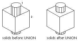
| (i) Union

|
With UNION, you can combine the total
volume of two or more solids or two or more regions into a new,
composite object.
To combine objects:
1. Select
Modify >
Boolean > Union (or click tool icon)
2. Select the objects to combine (1,2)
|
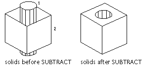
| (ii)
Subtract

|
SUBTRACT allows you to remove the common
area of one set of solids from another. One use that it might be put is
to add holes to a mechanical part by subtracting cylinders (i.e., holes)
from the object.
To subtract one set of solids from another:
1. Choose
Modify >
Boolean > Subtract (or click tool icon)
2. Select the object to subtract from (1)
3. Select the objects to subtract (2)
|
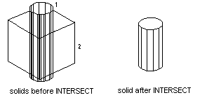
| (iii)
Intersect

|
The common volume of two or more
overlapping solids may be used to create a composite solid using
INTERSECT. The non-overlapping portions are removed and a new solid is
created. note that the command INTEFERE performs the same operation as
INTERSECT but it leaves the original two objects in place.
To create a solid from the intersection of two or more other solids:
1. Go to the menubar and choose
Modify >
Boolean > Intersect (or click tool icon)
2. Select the objects to intersect (1,2)
|
Temple Exercise (cont'd)
|
| Start |
Open the AutoCAD drawing file temple.dwg. |
|
Drawing Columns |
In the following section, you will take the
one simple circular column you drew in an earlier tutorial and be shown
two ways of turning it into a 3D column:
- extrude it into 3D, and
- use surface modelling to turn it into 3D
Then, you will turn it into a block, and copy it to each column grid
location. The use of blocks provides efficiencies and simplifies
updating when there are repeated elements. |
| Extruding the column
circle |
You can extrude 2D closed shapes by choosing the
Extrude tool on the Solids toolbar (or by entering EXTRUDE
at the command prompt). If the Solids toolbar is not displayed,
choose Toolbars from the View menu. Then select the
Solids toolbar from the list and check the checkbox.
The command will prompt you to select the object to extrude. Click on
the column circle. Enter 3000 as the height of extrusion. Press
Enter or the Return button on the mouse (right mouse button) to
select the defualt value (0) for the taper angle.
From the View menu, choose Zoom, then All (or
choose the Zoom All tool on the Standard toolbar to
display the entire 3D model. It should resemble the figure below.

Although very quick and effective, extrusion produces very simple 3D
shapes. Let's look at surface modelling methods for producing a more
interesting form. |
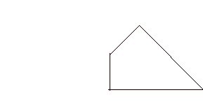
| Producing a
curved column |
This instruction will result in a curved
circular column and capital profile similar to the one in the figure
below.
You may produce a different profile if you prefer. Think about how it
will look as a 3D object, in later tutorials.
Set drawing layer back to grid (See earlier exercises for
method)
Zoom in to give magnified view of one column:
Command: z (Shorthand zoom command)
ZOOM All/ etc / Window/ etc : w (for Window)
Note that there are a wide range of other zoom options in the
selection line. The standard method of selection to key the character or
characters shown in upper case.
First corner:
Pick a point about 6000 (3 grids) above floor, and a similar
distance beyond the left edge of the floor
Other corner:
Pick a point below the floor lines, and beyond second grid line
Draw construction lines for half column
Command: l (Line)
From point: int (intersection)
Pick intersection of left grid and floor.
Object snap locational names (like int) can either be:
- Typed, as shown
- Selected after pressing the mouse right (Menu) button when the
pointer is in the drawing area
- Selected from Assist/Object Snap Sub-menu.
To point: @300<180 (300mm to left)
To point: @3000<90 (3000mm up)
To point: @300<0 (300mm to the right)
The examples above demonstrate how points, like movements shown
earlier may also be specified by the polar coordinate method. (ie.
distance from an origin and angle relative to the X axis).
Offset the top of column line up 200 to draw the construction line
for the top of the capital.
Command: Offset
Offset Distance: 200
Select object etc:
Pick the 300 long horizontal line you have just drawn
Side to offset:
Pick above the selected line
Draw half column profile - using arc command:
Set drawing layer to col
The method below is suitable for drawing an arc, by eye:
Command: arc
Center/: int
of
Pick point where column vertical construction line crosses floor
Cen/End/:
Pick bulge point, part way up shaft
End point: near
to
Pick position along horizontal top of column line. Arc will be
drawn fitting the points.
Evaluate the result:
Does it look like a column? If you wish to redraw it you could
consider two options:
- Undo. Make a clean start. Undo command is u
- Repeat process. Use the first attempt as a guide, then erase it on
completion. Erase command is e
Once you are satisfied, try a similar or another method, and draw a
profile for the column capital.
Command: qsave (save your work)
Draw other half of column - using mirror:
Command: mirror
Select objects:
Pick all of the half column. Press left button and drag window from
left to right, fully enclosing all column elements, but allowing other
lines to extend beyond the window. The left-right selection window,
selects only items that are fully within the window.
First point of mirror line: near
to
Pick any point on vertical, column centreline
to Second point: near
Pick another point on same column centreline.
Delete old objects?<N> :n (we want
both sides)
Other side will be drawn after
Finish your column, using commands you have employed earlier:
- change the layers of the construction lines you intend to
keep, to col. (eg. column and cap tops)
- trim and/or erase unnecessary linework Trim command
was usedabove. Erase command functions like copy or move.
Now zoom back to the wider view
Command: z (Shorthand zoom command)
ZOOM
All/ etc / Window/ etc : p (for Previous) |
| |
Copy column elevations:
Command: copy
Select objects:
hold down left mouse button. Drag window from left to right to
select the column, as described in the previous section for the mirror
command.
<Base etc>/Multiple: m (for multiple copies)
base point: near
to
Click on grid line of column to copy
Second point etc: perpendicular
Pick from Object Snap menu i.e. by pressing left mouse button or
using toolbar.
Move cursor to right and click on the next grid line. Another column
will be drawn after
Move cursor to the next grid line, select Perpendicular again,
as above, and four more times until the other columns are copied.
Command: qsave (save your work so far) |
| Drawing Lintel
Beam |
Zoom in to show elevation
drawing only:
Command: z (Shorthand zoom command)
ZOOM
All/ etc / Window/ etc : w (for Window)
First corner:
Pick beyond top left
Other corner:
Pick beyond bottom right
Draw 600 deep x 400 wide beam:
Set drawing layer to beam
Command: layer
?/Make/Set/etc: s (for set)
New current layer <col>: beam
?/Make/Set/etc:(to exit
command)
Try the next steps without detailed instructions. The following
approach, using the commands in bold, is but one of many possible
methods:
- offset the floor line, up by the height of the column and
capital - ie. 3200
- offset new line, up by 600 - ie. 3800 above floor
- offset both end column grids outwards by half the beam
width - ie. 200. Observe that the offset command repeats. You can
offset both with the one command.
- Use trim (see above) to cut the overhanging ends. Observe
that all lines can be selected and cut off with the one trim command
- Change layer of the newly drawn beam to beam.
|
| Drawing the
Roof |
The following method is
suggested:
- Set the drawing layer to roof
- offset the top beam line, up to the top of gutter level 300
above beam
- offset the new line, up another 1200
- offset both end column grids outwards by the roof overhang
plus beam width - say 450 to form the roof edge.
- change layers of newly drawn lines to roof
Extend the horizontal roof lines to meet the vertical edge of the
roof. For this operation a new command is best suited.
Command: extend
Select boundary edge(s)...
Pick both new vertical roof edge lines
<select object to extend>/Undo:
Pick both new horizontal lines, near all 4 ends. Each line will
extend when picked
(to exit command)
To finish off roof:
- offset the lower roof line 300 down, to form bottom edge of
roof, level with top of lintel beam
- trim ends of vertical lines to form ends of roof.
Command: qsave (save your work regularly)
|
| Drawing the End
Elevation |
The end elevation has four
column bays with the same spacing as the side elevation. It is possible
to produce this elevation without drawing anything but a few roof
lines.
To position the elevation, assume its right hand edge will be 13000
to the right of the corresponding edge of the side elevation.
You may need to zoom out, before proceeding, in order to fit the
extended image on your screen.
Copy right hand elements and 4 column bays:
Command: copy
Select objects:
Move pointer to just beyond the bottom right of the side elevation,
press Pick button and drag window from right to left and up beyond the
roof line, to include four right-most columns and the horizontal
lines.
<base etc>/Multiple:
Ignore location of cursor and simply click left button. Polar
co-ordinate method.
Second point etc: @13000,0 (13m to right)
Second point etc: (to
exit command)
Copy left hand elements:
Command: copy
Select objects:
Select left hand ends of roof, beam and floor, either by directly
picking the lines or by windowing (ie. by making a window as above)
from left to right.
<base etc>/Multiple:
Simply click left button as above
<base etc>/Multiple: @17000,0 (17m to right)
Second point etc: (to
exit command)
Trim off horizontal lines:
The roof lines will first be trimmed to act as construction lines for
the drawing of the gable end.
Try zooming in closer at this point, for better visibility. Use z
command and w option.
Command: trim
Select cutting edge(s)...
Select objects:
Pick left vertical roof line
<select object to trim>/Undo:
Pick each of the three horizontal roof lines, near their left hand
ends, one at a time. Each line should disappear as it is picked.
(to exit)
Next, trim the beam lines:
to repeat last (trim) command
Select cutting edge(s)...
Select objects:
Pick left vertical beam line
Select objects: 1 found
<select object to trim>/Undo:
Pick top and bottom horizontal beam lines
(to exit )
Next, trim the floor lines:
(to repeat last (trim) command)
Select cutting edge(s)...
Select objects:
Pick left vertical floor line
Select objects: 1 found
<select object to trim>/Undo:
Pick over-extended horizontal floor lines
(to exit )
Remove any unwanted duplicated items:
There could be some currently invisible, accidentally duplicated
lines, that need to be deleted. Use the Redraw option which you
can access via the menubar, View menu. The screen will also be
redrawn if you use either zoom or pan commands, but often
it is better to finish cleaning up before moving on to another view.
If any duplicate lines appear erase them:
Command: e
Select objects:
Pick unwanted objects
Command: qsave (save your work)
Draw gable end of roof:
Change zoom if necessary.Change current layer to roof
The construction lines will enable the sloping roof line to be drawn
from the intersection of the edges and gutter line across to the mid
point of the ridge level construction line.
Command: l (i.e., line)
..From point: int
of
Pick intersection of gutter line and left or right roof edge.
The other side may be drawn equally well by either of the following
methods:
- Repeating the above process.
- Using the mirror command. The mirror axis (requested if this
command is used) is the vertical line through the mid point of the
ridge level construction line, or the top end of the previously drawn
sloped edge
Any remaining construction lines can now be removed with the erase (e)
command. |
End of session
|
| |
That's all for now. Save your drawing (if you haven't
already) and then exit AutoCAD:
Command: end (to save and exit)
Remember to log off before leaving. |
|